
Getting Started 4. Downloading and viewing Gribs
![]() qtVlm not only displays Gribs over the maps/charts.. but can actually use the loaded Gribs to make an efficient course for your sailing boat..
qtVlm not only displays Gribs over the maps/charts.. but can actually use the loaded Gribs to make an efficient course for your sailing boat..
This article is to get you started downloading, loading and experimenting with Grib files in qtVlm ..and show you what kind of info is embedded in them.
Where do you get them ?.. all kinds of places, often for free. For UK users here's a good place to start:
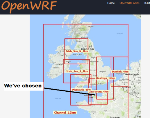
http://openskiron.org/en/openwrf
Go there and choose an area.. we've chosen mid Channel
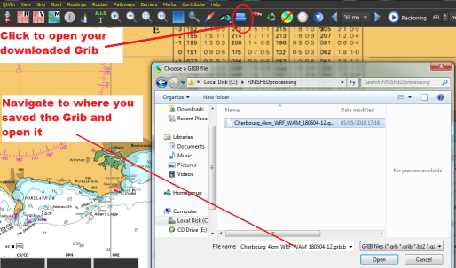
Get qtVlm going and use the indicated button to open the downloaded grib. Navigate to where you saved it and click Open.
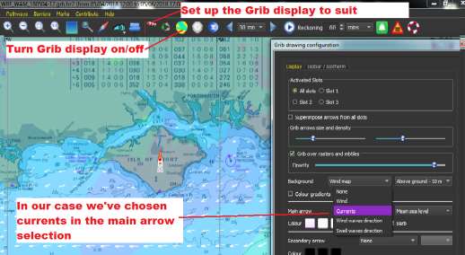
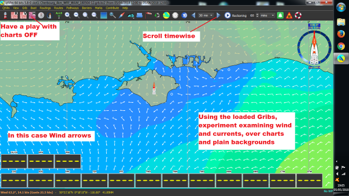
Set up the grib display to suit your needs, in our case we've chosen currents (tidal streams) as the arrows shown over the chart. There all kinds of possibilities to the display..have a little play.
Have a play with the charts on and off, plus charts locked at an overview level. Use the buttons to scroll timewise, experiment with wind, currents..and all the other info embedded in the grib. It's amazing what a range of detailed info there is in that downloaded grib. But it is time sensitive..a few days in advance.
In short this is your quick intro to downloading and viewing gribs in qtVlm. If you have a good experiment with getting, loading and discovering the scale of info embedded in that grib download.. we'll soon be ready to start showing you how to start using qtVlm to automatically leverage that into creating a custom route for your sailboat.
Comments from the qtVlm designers:
"On the grib page, of course the grib module can do much more (comparing, merging, etc). It is not necessary to open a web browser in order to download skiron's gribs. You can put the URL in "customized http address" for each slots, and access them directly. See documentation page 8 for a list of useful links you can put there. One can also download gribs with a few clicks, select a zone, right-click, etc. We are also Iridium GO! certified, but probably your typical users will never need that"
Coming soon: Polars, Weather/Tide routeing, and Simulation Mode (with real AIS targets)
For those with Windows machines (who may also want qtVlm on Android or iPad) UNIFIED CHARTS from mid April 2018 also support qtVlm (as well as the already supported programs and apps.) For those with Macs, Linux, RaspberryPi etc.. We now make CROSS PLATFORM charts that'll work on anything that qtVlm will run on. CLICK HERE