
You are viewing the expanded version of this Harbour,
for faster browsing
use the regular version here
Boscastle
Courtesy Flag
Flag, Red EnsignWaypoint
None GivenCharts
AC 1156 Trevose Head to Hartland Point; SC 5603.1A Lizard Point to Hartland Point; SC 5603.15B Port Isaac to Bude Bay; Imray C58 Trevose Head to Bull PointRules & Regulations
None KnownHazards
A SW to WSW wind of 4 or 5 produces a huge surge in this harbour and if you are in there and one is forecast you must get out.Tidal Data Times & Range
HW Boscastle is HW Dover – 0543. MHWS 7.3m MHWN 5.6m MLWN 2.7m MLWS 0.9m; Caution; that gives a Spring Range of nearly 21 feet (links)This site is designed for slower, roaming broadband connections, like you would get at sea, so it needs JavaScript enabled to expand the text.
General Description
Contacts
Harbour Master tel no 01840 250200 or 250635 or mobile 07967 112862
Coast Guard Lookout tel no 01840 250965 or mobile 07837 610 410
Boscastle is about 12 miles north of Padstow, just beyond Tintagel Head. This is a spectacular coast and just about every headland has an off-lying rocky islet which is pounded by the waves in a So’westerly. Boscastle Harbour has been formed by a combination of that pounding by the sea and the erosion of a small stream down from the moors. There are records of a pier of sorts here dating back to the time of Elizabeth the First and in the 18 and 1900s it was a major port for export and import into this coastline. Even then it could only be entered on the flood and then under tow and, in the days of the horse and cart, transferring cargoes up the hill from the harbour was a major enterprise. Being remote, Boscastle was well known as a smugglers haunt in the eighteenth and nineteenth centuries and even before that.
In more recent times Boscastle has been periodically subject to flash flooding from the moors behind it and finally burst on to the national stage in 2004 when there was a particularly large flood which caused devastation to all the buildings on either side of the “stream”. That damage has once again been repaired and stronger flood defences put in place but, as we sailors know, it’s a brave man takes on the forces of nature and expects to win.
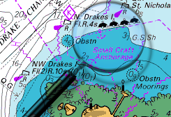
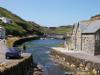
The entrance to the harbour is behind Meachard Island (once part of the coastline) and bends first port and then starboard to finally wind in between the piers into a drying harbour bound by walls built of diagonally laid slate. The channel in is steep to and has no hidden rocks along its margins but you will find it so narrow you’ll want to stay right in the middle and even then the cliffs feel as though they are just waiting to jump out on you! In any sort of a blow from the South West through to the North it is impassable as the waves bounce off the walls and intermingle to make it a maelstrom of white water. The other problem is that, although the placement of the piers would lead one to expect that the harbour is safe from swells, through some twist of hydrographical fate a SW to WSW wind of 4 or 5 produces a huge surge in this harbour and if you are in there and one is forecast you must get out of there. (There are stories of a visiting yachtsmen being virtually evicted by the HM in the middle of the night when such conditions were forecast) I have found a video of just such an event in 2008
Having issued all those warnings it has to be said that in the middle of the week, in summer and settled conditions this is one of the most beautiful places on this coastline and is well worth a couple of night’s visit. The main holiday trade is passing through (lunchtime on a Sunday in August has to be seen to be believed) and the evenings, when they’ve gone on to their destinations it turns into a peaceful heaven.
Approach
There are no off lying dangers on the trip from the South or the North;
...... your main problem will be identifying the right headland and off-lying island.
To help you, the headland just to the South of the entrance has a very conspicuous Coastguard lookout (which can be seen in our photos of the entrance). That Coastguard Lookout is now manned by members of the Coastguard Lookout Institution who hope to be able to communicate on channel 16 in the 2012 season.
You can pass either side of the island (Meachard), though some commentators recommend you come in from the South leaving the island to port if it is your first visit. Again, do not attempt entry in anything other than settled conditions. Once you have identified the entrance behind Meachard Island it is just a case of following your nose.
Berthing, Mooring & Anchoring
If you are twin (bilge) keeled you can either tie up bows on to the South pier
..... with a stern kedge laid out or come alongside further in. In one of our photos it would appear that there is a berth available alongside the inner stone pier but, from experience, that is used by the fishermen who come in on the last of the ebb to land their catches and the HM would ask you to move if you tied up there.
If you opt to come alongside the wall you would be advised to use fender boards or your fenders will be torn to shreds. This will be fun because remember there’s a ten to twenty foot range here and, if you rig fore and aft springs, the boards & springs tend to interfere with each other. The harbour does not supply fender boards but may be able to help with a couple of old tyres.
You should also note that the visiting yacht in our photo gallery has had to use a ladder for access at low water although there is evidence to suggest that they may be fitting some ladders in due course.
Ed Note There is now 2022 a ladder but you still need fender boards.
They will still (2022) only charge you a fiver a night to stop here
Facilities
There are modern public toilets at the end of the harbour from which you can obtain water. Most of the shops are for holiday makers but there are a couple of shops down by the bridge which can supply basic needs and there’s a petrol station and shop at the top of the hill on the road out to the South (and we mean “top”).
You will find a Youth Hostel in the village where you can get a shower for a consideration and if you ask nicely.
Eating, Drinking & Entertainment
Ah, the simple days; here there be a couple of pubs and restaurants at the bottom of the hill and that be it. There is a museum relating all the facts and figures for the recent flood but other than that there are the views and the cliff walks, best enjoyed when the visitors have gone home.
Links
|

Your Ratings & Comments