
You are viewing the expanded version of this Harbour,
for faster browsing
use the regular version here
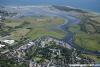
Christchurch Harbour
Courtesy Flag
Flag, Red EnsignWaypoint
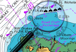
50:43'.6 N 001:43'.65 W Safe Distance Off, on the 2 m line.Charts
Admiralty 2035, 2172, SC5601Rules & Regulations
8 Knts speed limit in "The Run", 4 Knts InsideHazards
Very Shallow, Large Drying areas, 4.5 knts+ in the Run on the Ebb. Breaking Seas on BarTidal Data Times & Range
HW Springs -0210 Dover, HW Neaps -0140 Dover MHWS 1.8m MHWN 1.4m MLWN 0.7m MLWS 0.6m (links)This site is designed for slower, roaming broadband connections, like you would get at sea, so it needs JavaScript enabled to expand the text.
General Description
Christchurch was once an important port but is now badly silted up,
....... and visiting by boat is only possible for shoal draft craft on the top of the tide. The entry is complicated by a shifting bar and very strong tidal flows, as vast quantities of water from within the shallow harbour squeeze back out to sea through a very narrow area known as The Run.
The town itself is very beautiful, and the harbour is unspoilt and an important nature reserve with salt marshes, reefs and sand dunes. Some boat facilities can be found within, and the town offers useful shops, pubs and banks, as well as the Sailing Club. Other clubs are around the harbour.
Once through the rather intimidating entrance, the whole character of the place changes. This is a place where nature shows her more gentle side, and the owner of a shoal draft craft who makes the effort will be well rewarded. To be able to lay to your anchor in the midst of this beautiful scenery and chill out, whilst only been a few miles away from the money-grabbing hustle and bustle of the Solent is truly magical.
The only thing that might disturb your peace is the searchlight from the Christchurch Harbour Watch RIB, who patrol the waters at night for security reasons....
Approach
Christchurch Harbour is really only suitable for shoal draft craft, say 1.2m max, even at the top of spring tides.
It's important to note that Christchurch in common with many harbours in this area has a double high water (has four high waters a day). The Admiralty easy tide shows this clearly. At neaps the second high water tends to be higher, whereas on springs the first high water is the higher. The times given in the data in relation to Dover refer to the higher rise. Rain and river water have an effect on the depths within the harbour, and the speed of the outgoing flow through The Run. Even in normal circumstances it can flow between 2kn and 3kn, but in exceptional circumstances it can exceed 5 kn at times on the ebb. Christchurch Sailing Club have a good page for visiting yachts which adds to our description of the approach.
Christchurch Sailing Club : Visiting CSC
To give some idea of what you are facing there is a view in Google Street Maps showing the entrance at Low Water; note the dredger in operation! CLICK HERE
The Run is unstable and can often change in depth and in course, especially during the winter. Even in settled summer weather caution is needed. During periods of high pressure the depths of water within the harbour and the run in could be reduced by 0.3 m which is of great significance with so little depth to spare. With strong or prolonged winds from the South to the south-east a dangerous swell with a breaking sea on the bar can develop. Furthermore these winds rapidly affect the course and depth of the channel. The buoyage is organised by the Harbour Association, a voluntary body, and laid by a local boat. Caution should be exercised. Following the winterstorms the shingle is usually pushed across the entrance to the Run so depthsare unknown. Once the channel has been re-established the CHA go out and relay the buoys in the spring. Until then access is dubious and limited to about half an hour either side of HW.
There is less than 0.5 m on the bar, and this can be reduced further during easterlies. Within The Run it deepens out to around 2 m in places, but once within the average depths in the channel are less than 0.5 m, with a few deep holes of 2 m. The great majority of the harbour dries out to less than 1 m above CD.
This is obviously not a place for a deep keeled seagoing yacht to attempt, but with a shoal draft craft that can take the ground happily, this harbour has much to offer. A draft of 1.2 m at spring tides is probably the maximum possible, and for a proper exploration a draft of 1 m or less is better.
The entrance to the harbour lies about 1 mile to the NNE of the prominent Hengistbury Head, and it's off-lying charted shoals and rocks.... the safest course of action if coming from the West is to pass Hengistbury Head with a clearance of a least a mile, and to make for the Harbour and Buoyed Channel, when it is bearing between 310° and 290° from your position.
From the East, the entrance will be found to the East of Hengistbury Head, and identified by the buildings at the entrance, in particular a black house on the south side of the entrance. Make the approach from well out and well offshore on a bearing of about 290°. As the water gradually shoals to around 2.5 m (at CD), you should be able to pick up the buoyage, lying to the north-east of the harbour entrance. The bar and channel are constantly changing and the buoyage is shifted around to suit, so absolute positions can't be given. Make sure you identify the outlying red can and green conical buoys, and then follow the channel in, leaving the Reds to port and the Greens to starboard. It is assumed you have done your tidal calculations bearing in mind that the bar can have less than 0.5 m at LWS.
Follow the buoyage and it will lead you to The Run, which is less than 300 m wide and fronted by the Quay to the North and a shingly spit to the South. The deeper water is closer to the Quay, where the scour of the ebb has left the channel steep too.
Its important to locate the most outlying buoys before commencing your run in, and not to cut the corner of the shingle spit or to get confused by the green pile beacons on the beach. Stick to the buoyage.
After passing the black house the main channel trends southerly before swinging west and is marked by green conical buoys that you leave to starboard, and a little further on by red buoyage to port also.
Berthing, Mooring & Anchoring
The mooring possibilities within the harbour are either anchoring
.......... and drying out, a pontoon mooring at Christchurch Sailing Club, or a couple of drying boatyards. These are now described:
The channel makes a sharp swing to the West shortly after you pass a small jetty on your port hand side. The channel is narrow and it is important to follow the buoyage and not to stray.
Anchoring possibilities are very limited by the narrowness of the channel, and moorings taking up all the best spots. Basically anchor wherever you can leaving the fairway clear and not getting tangled with moorings. One suggested spot is opposite Grimbury Point. The shoal draft cruiser prepared to take the ground obviously has many more options.
Continuing along the narrow channel will bring you to Christchurch Town, where a T-junction forms, the River Avon and the River Stour meeting head-on and joining the channel to the sea.
Dead ahead at this junction is the Priory Quay developement with a private (very) Marina and pontoons just outside it; these are not available to visitors and if you tie up there you'll be as welcome as the seagulls spoiling their lovely paintwork!
Slightly to the West of this junction on the Northern bank lies a very useful pontoon belonging to Christchurch Sailing Club, directly outside their premises. Visitors from other yacht clubs are welcome to use the eastern side of this pontoon, which has room for only a few yachts. There are also a couple of clearly marked visitors moorings. Call in at the club and pay the bar steward who will issue an invoice. Visitors can use all the club facilities, telephone 01202 483150... the club is shut on Mondays.
Christchurch Sailing Club : Visiting CSC
Update 2021 Rossiters Boatyard has been taken over by Avon Marinas and does not cater for visiting boats. Elkins Boatyard opposite them also no longer has room for visiting boats
Facilities
For the boat the sailing club pontoon offers limited electricity and water is obtainable.
Other clubs, boatyards, and Marine engineers are available in this harbour, check the directory.
Launching and recovery of trailer boats is possible at Mudeford Slipway, available for three quarters of the tidal range. Pay and display parking is available and there are toilets and a pub too.
Unless the Sailing Club can oblige the nearest auto diesel is at a filling station just over 15 minutes walk away
The town offers all the usual facilities and has a Monday market, With Dorset farmers market on the first Friday of every month.
Transport is well connected with the mainline railway station, and buses too. Bournemouth International airport is only a few miles away.
More Info
History
The town was originally a Saxon settlement called Twyneham (which gives the town's central school its name), from "betweon eam", which meant (the settlement) between two rivers.
During Saxon times the harbour was one of the most important in England as it was easily reached from the continent and boats could enter the harbour and travel up the river Avon all the way to Salisbury. The sheltered harbour and easy access to neighbouring towns also made the area popular with smugglers, culminating in the "Battle of Mudeford" in 1784 between Customs & Excise and the smugglers. There was a Saxon mint (coin) in "Twynam" until just before the Norman Conquest.
Demographics
The borough has a population of 44,869 (according to 2001 figures), of whom a significant proportion are comfortably off senior citizens (33.1% of the population are of retirement age). Indeed, the area of Highcliffe on the borough's eastern boundary possesses the highest percentage of elderly residents in the entire United Kingdom (70%).
Present day
The Avon and the Stour both enter the sea in Christchurch Harbour. This medium-sized priory and market town is generally regarded as a conservative, slow-paced and popular tourist and retirement destination "where time is pleasant" (according to the town's official description). The older part of the town, dominated by the Priory Church (the longest parish church in England), dates from Saxon times and still retains its Saxon street layout. It is an interesting mixture of picturesque walks, quaint houses, restaurants, public houses and coffee shops, some of which date back to smuggling times.
In Christchurch there are several reserved buildings including the thatched 14th century Old Court House and the Georgian Red House.
The town centre is dominated by Christchurch Priory and the High Street with its squares and parades containing shopping facilities. Christchurch forms part of the south east Dorset conurbation along with Bournemouth, Poole and adjacent areas of East Dorset.
The harbour is a large protected salt marsh protected by a sand bar at the entrance. The harbour is only accessible to shallow draught boats due to the sand bars at the entrance. The entrance, known as the Run, has Mudeford Quay on one side and the sand bar on the other. Considerable tides flow here, up to 6 knots during spring tides. The harbour is a protected wildlife refuge and is home to large populations of swans, waders and other bird life. On the south side the harbour is enclosed by Hengistbury head which was the site of the earliest settlement here dating back to the Neolithic. The landward end of the headland still has the bank and ditch built about 2000BC to protect the settlement.
Stanpit Marsh Local Nature Reserve is situated just below the confluence of the Rivers Avon and Stour. During the 18th century it was notorious for smugglers landing tobacco and rum in the narrow channels of Christchurch Harbour. It comprises areas of saltmarsh, freshwater marsh with reed beds and areas of scrub. It was designated as a Local Nature Reserve in 1964 and in 1986 as a Site of Special Scientific Interest. It is approximately 65 ha in area and is managed by Christchurch Borough Council.
Nearby is Highcliffe Castle, a Grade I listed building. The castle was designed by William Donthorne for Charles Stuart, 1st Baron Stuart de Rothesay, and built between 1831 and 1835. It stands on the site of High Cliff, a Georgian mansion that had belonged to Charles Stuart's grandfather John Stuart, 3rd Earl of Bute.
The Member of Parliament for the Christchurch constituency is Christopher Chope, who holds a considerable vote majority of 15,559 and a percentage vote of 54.7% following the 2005 general election, making Christchurch one of the safest Conservative constituencies in the country.
The text on this HISTORY page is covered by the following licence
http://en.wikipedia.org/wiki/Wikipedia:Text_of_the_GNU_Free_Documentation_License
Eating, Drinking & Entertainment
Whilst mentioning that on busy weekends and bank holidays it may be worth booking in advance for eating out, it is beyond the scope of this guide to delve too deeply. Suffice to say all tastes and price ranges are catered for in Christchurch, and checking the links below may give some ideas:
Things to do http://www.visitchristchurch.info/site/things-to-do
Pubs www.beerintheevening.com/pubs/results.shtml/el/Christchurch%3BDorset/
Eating out Restaurants & Places to Eat in Christchurch 2021 - Tripadvisor
Links
|
Your Ratings & Comments
Navigation wasn't as traumatic as we thought it might be. Unfriendly waves at the bar on the seaward side of the channel as we left, in a solid f4 SW but not a problem though wouldn't fancy it in anything much stronger as one could potentially sweep you out of the channel.
The river is very busy at the weekend, especially around HW when boats are leaving or arriving.
Can confirm that the fish and chips from Priory chippy are still very good indeed and not ruinously expensive as I thought when I saw "artisan" on their signage.
Unsurprisingly, the priory is still good - spent a lot longer in there than expected. The upstairs museum is worth climbing the stairs for.
Getting into the harbour remains a challenge but the difficulty is sometimes exaggerated. We came in in a boat drawing 0.9m with about 1m of tide and always had at least a few inches under the keels. Stay in the middle of the marked channel, do it on a rising tide (obviously) and don't try it with a deep keel.
The Priory Fryer in the High Street does excellent fish and chips with unusually delicious batter. The Priory itself, said to be the largest parish church in England, is also worth a visit - and its tower is a landmark visible from seaward. The quality of the town can be deduced from the presence of Waitrose and Marks & Spencer as the only two supermarkets in the town centre. The Boathouse pub is trendy and ruinously expensive.