

Harbour Information (use the  icons to find out more)
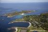
The Scilly Islands- Saint Agnes and Gugh
Your Comments: 3 Read or add your comments
Courtesy Flag
Flag, Red EnsignWaypoint
None GivenCharts
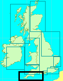
AC 1148 Isles of Scilly to Lands End; 34 Isles of Scilly; 883 Isles of Scilly and the Principal Off-Islands; SC 5603 (8 to 13) Various parts of the Isles of Scilly including small scale Falmouth to Scillies; Imray C7 Falmouth to the Scillies and Trevose Head (insufficient on its own)Rules & Regulations
See TextHazards
PlentyTidal Data Times & Range
HW St Mary’s is HW Dover – 0630. MHWS 5.7m MHWN 4.3m MLWN 2.0m MLWS 0.7mThis site is designed for slower, roaming broadband connections, like you would get at sea, so it needs JavaScript enabled to expand the text.
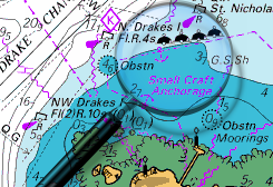
Approach
There are no particular problems approaching either the Cove or Porth Conger.... ... read more
Berthing, Mooring & Anchoring
You can anchor in Porth Conger, The Cove or,,,,, ... read more
Your Ratings & Comments
3 comments
UPDATE SPRING 2021
Written by Don Thomson 3 | 15th Apr 2021
I reviewed these notes in April 2021. I haven't heard of any changes here
UPDATE SPRING 2018
Written by Don Thomson | 3rd May 2018
No changes
Update Spring 2016
Written by dononshytalk | 12th May 2016
These notes were reviewed by Don in May 2016. No changes.

© visitMyHarbour.com | website design created by Black Culm Ltd