

Harbour Information (use the  icons to find out more)
Skerries
Your Comments: 6 Read or add your comments
Courtesy Flag
Irish TricolourWaypoint
None GivenCharts
AC 44 Nose of Howth to Ballyquintin Point; AC 633 Skerries Islands; Imray C52 Irish SeaRules & Regulations
NoneHazards
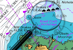
The Skerries are surrounded by drying reefs and off lying rocks; stay well outside them unless you have the large scale chart of them on board (AC 0633-2)Tidal Data Times & Range
Tides are as Balbriggan to the North: HW is HW Dublin – 0020, LW is LW Dublin + 0005; MHWS 4.4m MHWN 3.6 no data for LW, it dries throughoutThis site is designed for slower, roaming broadband connections, like you would get at sea, so it needs JavaScript enabled to expand the text.
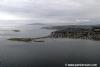
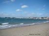
General Description
Contacts: Skerries Sailing Club VHF #72 (when racing) tel +353-1-8491233 ... read more
Berthing, Mooring & Anchoring
In all probability you will have to anchor off here unless..... ... read more
Your Ratings & Comments
6 comments
UPDATE OCTOBER 2022
Written by Don Thomson 3 | 21st Oct 2022
No changes
UPDATE SUMMER 2021
Written by Don Thomson 3 | 13th Sep 2021
No changes
Update Summer 2019
Written by Don Thomson 3 | 29th Jul 2019
These notes were reviewed in July 2019. No changes were necessary but the charts have been updated.
UPDATE APRIL 2017
Written by Don Thomson | 26th Apr 2017
These notes were updated in April 2017. The charts were updated; otherwise no changes
Update 2015
Written by dononshytalk | 20th Apr 2015
These notes were reviewed again by Don in April 2015. We have added a link to their sailing club
1 of 1 people found this helpful
Update December 2013
Written by dononshytalk | 11th Dec 2013
These notes were reviewed on 11th December 2013; no changes were necessary
1 of 1 people found this helpful

© visitMyHarbour.com | website design created by Black Culm Ltd