
You are viewing the expanded version of this Harbour,
for faster browsing
use the regular version here
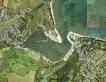
Bembridge Harbour
Courtesy Flag
Flag, Red EnsignWaypoint
Just N of Tidegauge 50:42'.51N 001:05'.008WCharts
Admiralty 2022, 2037, 2045, SC5600 (links)Rules & Regulations
6 Knts Speed Limit, No Anchoring (see text)Hazards
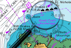
Shallow Twisting Entrance ChannelSubmerged Barrier between Portsea and the Horse Sands Fort. Dolphins mark the safe passage.
Tidal Data Times & Range
Long Stand HW, HW approx +0014 Dover MHWS 3.1m MHWN 2.3m MLWN 0.5m MLWS 0.2m Tide tables: (links)This site is designed for slower, roaming broadband connections, like you would get at sea, so it needs JavaScript enabled to expand the text.
General Description
Contact: Harbour Office tel 01983 872828
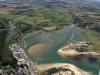
Bembridge Harbour is a largely drying lagoon on the East coast of the Isle of Wight, bounded by sand spits on the seaward side and accessed via a twisting,dredged channel running in from abeam St Helens Fort.
As a result of the previous owners going into liquidation in 2011, the Harbour is again privately owned by Fiona and Malcolm Thorpe who live on the Island.
The Harbour is still managed by the Bembridge Harbour Improvement Company which acts as the Bembridge Harbour Authority ( www.bembridgeharbour.co.uk )and consults with local stakeholders and the community via the Bembridge Harbour Advisory Group. The Thorpe’s took over in 2012 and, as far as we can see, the harbour has improved since then with better facilities ashore and afloat. It is well worth visiting their website as they have various offers and attractions for the visiting sailor and, since they took it over, Malcolm and Fiona have made great strides in improving the facilities.
Note Sept 2023: The Thorpe's have now finally had enough (lots of local bickering and back-biting) and are trying to sell. Expect changes in the future.
The entrance channel follows a tortuous twisting route from the area of St. Helen's Fort to Bembridge Point.
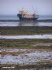
Once in the harbour itself there is a dredged access channel for the visitors moorings on the Duver pontoon, and to Bembridge Marina deeper within. Careful tidal calculations are required before attempting entry, the results of getting this wrong, or misinterpreting the buoyage can be seen in the photo gallery.
It is hard to believe that at one time the sea made its way as far inland as Brading, and ships could work their way there. Now all is silted up, and what remains is a fairly large expanse of shallow water much of which dries. Access to Bembridge Harbour is dependent on the depths of water available in the entrance channel which can vary not just according to the height of the tide but also by the constant shifting of the channel. The least depths are liable to be found in the first part of the approach.
The buoyage is well maintained (although unlit) and is shifted around to suit changes in the channel, and strangers should have no problem getting in providing they have done their tidal calculations correctly. Boat drawing 1.5 m can normally get in three hours before high water, deeper draught vessels obviously leaving it a bit later. First-time visits are best tackled on rising tide, with meticulous attention paid to following the numbered buoys. Once inside shelter is good and as a result of massive dredgeing in 2012 there is now in excess of 2m on both sides of the Duver Pontoon
The scenery is pretty, with excellent beaches and welcoming yacht clubs. Provisioning is a bit trickier with quite a hike needed to accomplish a decent stock up, as the visitors pontoons at the Duver are a bit out of the way to say the least.
Small craft able to take the ground can dry out on the beach just inside the entrance on the port hand side. From this spot access to Bembridge Village and hence shops etc is straightforward.
Approach
Getting into Bemberidge Harbour is not difficult but will require some tidal calculations and close attention to detail...
Because when following the buoyage it easy to get confused (and thus run aground). In any kind of approach it is necessary to identify St Helen's Fort, which is the smallest of the Solent forts. Approaching from the North, the extent of Ryde Sands must not be underestimated, and if approaching from the South it is essential to keep well clear of the Bembridge Ledges. See the photos covering both these dangers at low water.
The Tide gauge is removed during the winter and is replaced each Spring. There is now also a live feed on the harbour website which features at the top right hand side of every page on the site.
If you are certain there is enough water for you, cautiously head in a South westerly direction and pick up the buoyage, starting with the green number one and the red number two (both of which are lit). The buoys are spherical with top marks. The Greens have odd numbers and the Reds have even numbers. This can be the confusing part, as when the tide is in and the Sands covered it is easy to misinterpret this buoyage. Providing you follow the numbers all will be well, pay no attention to yellow buoys.
To help you at the planning stage we have uploaded a copy of the approximate approach buoyage and there is a video of the buoyage on their website at http://www.bembridgeharbour.co.uk/Navigation/Video-of-Channel
The shallowest narrowest part is covered by the first three green and red buoys, after this it deepens out swinging southwards and running parallel to the beach.
Once through the entrance and after passing green buoy number 11A, a swing is made to starboard and the Duver pontoon will be seen ahead on your starboard side, with red buoyage marking the limits of the channel on your port hand side.
Bembridge Marina lies further into the harbour, and its berths are filled by residents only. Should you need to get there It is simply a matter of following the buoyage. There is a series of slides on the Bembridge harbour website (Link below) which give an excellent view of what to expect on the way in.
In addition to these instructions there are detailed instructions and photographs for entering Bembridge on the Harbour website (Click here) There is also a video of the inbound passage which can be accessed directly Click here
Berthing, Mooring & Anchoring
Visiting yachtsmen or motorboaters will find the harbour authorities have established a visitors' pontoon at the Duver, where most boats will be able to remain afloat at all sides of the tide.
Although there are many other moorings within, most are for locals only. Anchoring is not allowed anywhere within Bembridge harbour, or within 200 m of St Helen's Fort with the exception noted below:
Catamarans and bilge keelers are allowed to run up and to dry out on the sandy beach just inside the harbour on your port hand side, more or less in front of Bembridge Sailing Club. This will involve anchoring fore and aft if staying awhile. You will be charged £10 per night
The huge advantage of being here is easy access to Bembridge Village, furthermore there is a cafe virtually on the spot and a pub more or less opposite. Deeper keel boats lying on the Duver pontoon have no such luck.
The Duver pontoon has been established to accommodate visitors, and has Water and electricity. If intending to moor here sail past the fuel pontoon at Atrill's Yard, and the Duver pontoon is on your starboard side. Get tied up where you can, rafting out is normal during busy periods. The further out you are rafted the deeper the water. A member has advised us that it can be awkward getting off this pontoon in Southerlies; his note in the comments below is worth a read.
Prices (2023) There is an on-line booking service which has a copy of a variable pricing policy. also note that they are charging a base £6.00 a night for a shore pwoer hook up
Visitor Berthing (bembridgeharbour.co.uk)
They have a Loyalty Scheme for frequent visitors.
Bembridge Marina deeper into the harbour has no visitors berths available, and the Fisherman's Wharf is unlikely to have any either.
The harbour authority is in charge of all the moorings within the harbour, and they can be contacted on VHF channel 80 " Bembridge Harbour", or telephone 01983 872828. Harbour staff work three hours either side of HW Portsmouth, but the office keeps normal hours. Link to their excellent website below:
http://www.bembridgeharbour.co.uk/
The harbour authority suggests that you call before approaching if you have a large or unmanoeuvrable vessel, and also during peak periods. They do not take advance bookings of any kind, but will do their best to find you a suitable berth. They point out there are unlikely to be any staff on duty between 2300 and 0800.
Further Berthing Information
"The beaches around Bembridge are great for the kids and there are good walks around the shoreline. If you can take the ground you can anchor in fairly sheltered water just outside the harbour, close to the beach, and avoid all charges. You can pull up onto the (fairly steep) beach inside the harbour on the port hand side and you are close to the outer beaches. There is a charge here, but it's reasonable....
When the May Bank Holiday (2006) promised to be blown out we decided to make a quick dash over to Bembridge, this being the only viable place without a hard beat in strong wind. Others had the same idea so we were four out from the pontoon and were charged £18.70 per night. The permanent loo block and shop are now in operation. There are a couple of gas barbecues close by the cash office which can be used by visitors for a contribution toward the gas.
The Brading Haven Yacht Club open their doors to visiting crews and a good meal and a drink can be enjoyed in the clubhouse or on the terrace overlooking the harbour. Walking further round the harbour, past the house boats, brings you to a fairly well stocked chandlery then the Bembridge Sailing Club. Opposite BSC is a pub, the Pilot Boat Inn, which is reportedly worth a visit.
From here you can take a footpath over the hill that will bring you to the lifeboat station. The 'Lifeboat view' cafe on the sea wall serves all sorts of refreshment. The walk back, along the beach, completes the circuit."
This information is reproduced here by kind permission of Alan Holmes, his site below has much information about Solent harbours and anchorages, has some good photos, and is based on plenty of hands on experience...check it out
Facilities
If on the Duver pontoon you will find water and electricity (£3.00 per night) as well as showers, toilets and laundry facilities. There are also supplies of Calor Gas & Camping Gaz refills at the chandlery. We are told that the amenities block is not up to the standards of other similarly priced marinas.
Diesel is available in small quantities is available from Atrill's yard but, unfortunately the nearest petrol is the Tescos in Ryde.
There are a couple of boatyards with lifting facilities should repairs or storage ashore be required, see the directory.
There are two clubs in Bembridge... Brading Haven Yacht Club offers hospitality to visiting yachtsman. Their premises are adjacent to Bembridge Marina, deep into the harbour (and nowhere near the Duver). Telephone them on 01983 872289, and a link is provided below:
Bembridge Sailing Club welcomes visitors from RYA affiliated Clubs to use their bar and catering when it is available. Showers are available here with a £1 charge. They are located close to the beach just inside the harbour entrance, therefore a short dinghy hop across from the Duver pontoons. Call them on 01983 872237 and check their website below:
http://www.bembridgesailingclub.org/
If on the Duver pontoon there is a licensed delicatessen opened from 8:30 AM, but basically nothing else apart from a beach cafe near to the sea mark. To get anywhere from here (other than by dinghy or water taxi) involves quite a hike. The village of St Helen's (inland) is perhaps the closest, but there is no chance of even a remotely decent stock up here. A Post Office (with cashpoint) and a tiny local store.. that's it.
New for 2014. We are told that there will be a small provisioning facility for basic supplies within the berthing office at the root of the Duver pontoon from Easter 2014
To get to Bembridge Village involves a walk over the causeway (which you would not want to tackle in the dark), and then coming back on yourself along the road fronting the southern side of the harbour. When you get to Bembridge Sailing Club you are fairly close to the town. This is really not to be tackled lightly as it involves circumnavigating the large expanse of the harbour on foot. The easiest option is to launch your dinghy (pain though it might be) and land on the beach that's just inside the entrance in front of Bembridge Sailing Club. From here you are close, not only to the town but also to the chandlery.
The alternative is to try the Bembridge Water Taxi by calling VHF channel 80 or telephone 01983 872828. They operate three hours either side of high water and will be able to get you close to the town.
Bembridge itself offers a butchers, bakers and a delicatessen. There is a David's (local Isle of Wight convenience stores) supermarket, and this has a cashpoint. A Post Office, a chemist and a Lloyds TSB (sans cashpoint) also reside here. So too do several pubs and restaurants....
Keep an eye out for the unique 1921 style phone box, from the days when the good old Post Office used to (mis)manage the phone network. Remember the days when you could pile into a phone box, close the door behind you and make a phone call in some peace and privacy complete with volumes of paper phone directories. You may also recall, the phone boxes often used to have a somewhat dodgy odour within...
Transport links from Bembridge are covered by Southern Vectis buses and connect with Ryde, Sandown and Newport.
History
Background
It had a population of 3,848 according to the 2001 census of the United Kingdom, leading to claims by residents that Bembridge is the largest village in England, and occasional claims that it is the largest village in Europe. The mean age of the population is 50 years old.
Bembridge is a local service centre, hosting both a primary and middle school a post office, several shops, a local airport (with concrete runway), and Catholic, Methodist and Anglican Churches. It is also the location of a local fire station, (crewed by a team of retained firemen), and a Royal National Lifeboat Institution (RNLI) lifeboat station.
One notable district is Lane End. It is largely composed of modern bungalows and a small shopping area which includes a Co-Op store. The lane comes to an end at the beach, where Bembridge Lifeboat station and the Bembridge Coast Hotel are situated. Formerly many of the bungalows were on the land of a cottage where Cecily Cardew lived, after whom an Oscar Wilde character was named.
The RNLI station is particularly significant, as extending into the sea to the east of the village lies the notorious "Bembridge ledge", a large rocky outcrop which poses a major threat to passing boats. Although it is private sailing yachts which are most at risk, a wide variety of boats commonly run aground here, especially in the often stormy weather conditions which affect the Solent during winter months.
Close to the lifeboat station lies a coastguard outlook. Positioned at a high elevation this offers views of the Solent meeting the English Channel to the east of the Isle of Wight. From this vantage point one is able to view a variety of watercraft year round, although there is more marine traffic in the summer. Adjacent to the coastguard outlook is the Crab & Lobster pub, popular for its locally-caught seafood. Other popular seafood locations around Bembridge include Baywatch On The Beach, The St. Helens Restaurant and the Lifeboat View.
Public transport to Brading, Newport, Ryde and Sandown is provided by Southern Vectis bus routes 10 and 14.
Bembridge Windmill, the only remaining windmill on the Isle of Wight is located to the west of the village. Dating from around 1700, it is a National Trust property generally open from April to October.
The Britten-Norman aircraft factory is located near Bembridge.
Brading
Early history
From early times, Brading ranked as an important Island port. The ancient name of Brerdynge, from which 'Brading' is derived, probably meant (according to 'Place Names of the Isle of Wight') the people living by the ridge of the Downs and dates from at least 683.
The Roman Villa south of the town, as well as the numerous relics of the Roman period discovered in the area, show that this was a seaport of some note 2,000 years ago. Signs of prehistoric activity have also been found on Brading Down.
Local history records that St Wilfrid came to the Island during the 680s, landed at Brading, preached there to the Islanders and began the conversion of the Island, possibly establishing his first church there. Bede states that King Caedwalla of Wessex killed the pagan population "with merciless slaughter" and replaced them with his own Christian followers, dedicating a quarter of the Isle of Wight to Wilfrid and the Church. Wilfrid would thus have been literally preaching to the converted because everyone else was dead. This legend was illustrated by a tableau at the Waxworks.
Royal charter and governance
The charter granted to Brading by Edward VI in 1548 makes reference to a previous charter granted by Edward I in 1285. The charter allowed the town to hold two annual fairs.
Nowadays the fair is called Brading Day and is held over the 1st weekend in July each year.
In recognition of its status as a town, Brading still has a mayor and an elected town council.
In mediaeval times the town was governed by the Steward, Bailiffs and 13 Jurats, and returned two MPs to the Westminster Parliament. Now the town is a part of the Isle of Wight parliamentary constituency.
The old port
Until the 16th century the port was active. Ships lay alongside at the quay behind the Bugle Inn in the High Street. Ships came into Brading Haven for shelter and for provisions, particularly water, which was of a high quality. The north-eastern part of the haven was closed off by an embankment completed in 1594, much of which is still present. Ships would then tie up at the far end of Quay Lane on the other side of the embankment.
Throughout the Middle Ages various attempts were made to drain off the rest of the harbour; for it had gradually become silted up and, except for the main channel of the river, was too shallow to be of any commercial use. Sir Hugh Myddleton, who had constructed the New River from Enfield to central London for James I, undertook this work; but the sea broke in and flooded the land once again. After others had also tried and failed, this reclamation was finally accomplished in 1881 by the building of a substantial embankment right across the harbour, with the building of the railway to Bembridge.
So Brading now shares with Winchelsea and Romney the distinction of being a seaport without any sea. Losing access to the sea caused Brading to decline in importance and prevented the sort of growth enjoyed by Cowes and Newport.
The Town Hall
The Sundial, Brading, circa 1910A historic Old Town Hall stands near to the church. The New Town Hall dates from 1903. There is no record of the earliest Town Hall, but an entry in The Court Leet Book 1729 refers to the assessment of one shilling rate, and also a subscription towards building a new Town Hall, Market House and Prison. In 1730 an extra 3d was added to the rate for the Town Hall.
This new building remained until 1876 when it was restored to its present state, and then contained the Free Town Library. Before the building of the first school in 1823, the children were taught in the Town Hall, and it was also used for Mother's Meetings. The Town Trust now owns the building.
Brading was formerly the testing place for weights & measures for all of East Wight and these standards are still kept in the upper building together with the Town Charter.
The Bull Ring
Set in the ground outside the new Town Hall (1903), there is an iron bullring which was once used to secure a bull whilst it was being baited by dogs.[3] According to the diaries of Sir John Oglander, the Governor of the Isle of Wight would donate 5 guineas for the purchase of the bull to be baited; the meat was afterwards donated to the poor of the town. The Mayor attended this ceremony in full regalia and a dog, known as the Mayor's Dog, would be decked with coloured ribbons and set on the bull after the proclamation had been made. A large wooden carving of a bull decorates the Bullring. This is by local artist Paul Sivell. Another of his works is an approximately 10 foot wooden statue of the goddess Diana postioned in the woods above Brading at Kelly's Copse entitled "For Camilla". This commemorates a recent murder of a Danish exchange student by a sex attacker from Gosport. Many local people have added plastic flowers and stuffed toys as tribute.
The Town Gun
The town possesses a gun. It is a brass piece, made in 1549 by the Owine Brothers, John and Robert, so that the town might be defended from French invasion. The gun was never used in action, but was taken to the top of Brading Down in 1832 so that it could be fired to celebrate the passing of the Reform Bill. Unfortunately it exploded and split, putting a stop to celebrations for the day. In the 1950s it was stolen from the "Gunne House" behind St. Mary's Church and was found in a sale room in Kent. It was returned, however, not to the Town, but to the Oglanders at Nunwell House, where it remain's beneath Fanny Oglander's bedroom window. The Town Trust has asked for it back, but Fanny Oglander has said that security arrangements should be improved and the matter remains unresolved.
Wildlife and Landscape
The southern half of the town is designated as an "Area of Outstanding Natural Beauty". There are two Sites of Important Nature Conservation close to Morton and another on the downs.
Brading Down is a popular viewpoint and downland beauty spot, with impressive views over Culver Down and Sandown Bay. From the north side of the hill you can look over the town towards the mainland. From further up you can see the Solent and the Spinnaker Tower at Portsmouth. This elevated site is also of great archaeological importance, with prehistoric, Roman and mediaeval remains, as well as practice trenches from the first world war.
The Brading Marshes nature reserve is the first Royal Society for the Protection of Birds reserve on the Isle of Wight. Situated on the reclaimed land of the old harbour, behind the present-day Bembridge Harbour, it was bought in 2001 and is a mix of lagoons and ditches, reed beds and meadows, with a fringe of ancient woodland.
Transport
Brading is served by Brading railway station on the Island Line Railway with direct connection to the Wightlink ferry at Ryde Pier Head and stops at Ryde, Smallbrook, Sandown, Lake and Shanklin. Brading is also on the Island’s circular cycle route used for the annual “Bicycle Island Randonée”.
The main A3055 road from Ryde to Sandown passes through the town.
The town is well-connected to the surrounding countryside by footpaths and bridleways. The Bembridge Trail passes through the town along Doctors Lane, Cross Street, High Street and Quay Lane (Wall Lane) then along the top of the embankment to St Urian's Copse. There are 71 other footpaths, by-ways and bridle paths in the civil parish area and organised parties of walkers may often be seen meeting at the station or the Bullring.
Southern Vectis run buses on route 2, route 3 and route 10 from the town, serving Bembridge, Newport, Ryde, Sandown, Shanklin and Ventnor, and some other places. Night buses are run at weekends.
Features of the Town
The main street of Brading contains most of the facilities expected of a large village, or in Brading's case, small town. There are four pubs; The Bugle Inn where the sea almost met the High Street when Brading Haven was a major port, the Wheatsheaf Inn which faces the Bull Ring, the Smart Fox restaurant, and one at nearby Yarbridge named the Yarbridge Inn which is famous for its selection of real ales. St. Mary's Church, Brading is at the north end of the town and the Methodist chapel is near the centre. There is a small supermarket, a post office, a newsagents, several other specialist shops, at least three teashops and a fish and chip shop.
Brading has many attractions to tempt the visitor, quite apart from the natural beauty of the area. These include the famous Brading: The Experience (formerly the Isle of Wight Waxworks Museum); the Lilliput Doll and Toy Museum; The Roman Villa at Morton with its protective cover (new in 2004) and interpretation centre.
Eating, Drinking & Entertainment
Although a bit of a hike, the village of Bembridge can offer a few pubs and a couple of restaurants. If planning an evening out don't forget that you may have to walk back to the Duver pontoon via the causeway in the dark and a torch would probably be a good idea.
The closest place to get a drink and a meal (if walking) will be the Brading Haven Yacht Club which welcomes visitors and is adjacent to Bembridge Marina.
If going across in the dinghy or water taxi to the beach just inside the harbour entrance, you will find the Pilot Boat Inn close by ashore, also serving food.
If you care to delve further into Bembridge, the Crab and Lobster Inn has good views and provides bar meals with an evening restaurant. Unsurprisingly it specialises in seafood.
For those with time to explore Bembridge properly there is an art gallery, a windmill dating from 1700, and Bembridge lifeboat station is open three afternoons a week during the summer for the public.
For those tempted to give Bembridge miss and try the closer St Helens, sorry to tell you that if you're on the Duver pontoon you still have to tackle the causeway, or make an extremely long detour. This involves following the beach around as far as the seamark (where you will find Baywatch on the Beach serving meals and snacks) and then following the Duver Road inland to St Helens.
The village of St Helens has one pukka pub, The Vine, and a couple of bistro style restaurants.
It has been rightly pointed out that for young people there is not much to do around this whole area. If you have youngsters on board Ryde may be better, likewise if you are not up for long hikes.
For those who enjoy a scenic and beautiful setting and enjoy long country walks and sea views Bembridge is well worth visiting.
Links
Interesting website about the Solent Forts, with good photos too !
http://www.bobleroi.co.uk/ScrapBook/Solent/Solent.html
|

Your Ratings & Comments
The little shop in the office carries a surprisingly varied selection given its limited space.
The coastal path back from the Bembridge lifeboat station is currently closed but you can walk back along the beach.
My tips would be to look at the forecast and see which way the wind is forecast for your departure since if you call the Harbour Master you may be able to berth on the far side of the pontoon (something I should have done before my last visit at the weekend).
Secondly, if the wind is strong and blowing you beam on to the pontoon then talk your departure through with the Harbour master - these guys see tens of boats leaving every tide and know what works - they are there to help.
Thank you to the Harbour Master on duty on Sunday 6th April 2014 for getting me off first time without a hitch.
Roger (Storm Dragon)
View all 12 feedback items