
You are viewing the expanded version of this Marina,
for faster browsing
use the regular version here

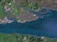
Canvey Area (inc Southend, Leigh on Sea, Benfleet, and Holehaven)
Courtesy Flag
Flag, Red EnsignWaypoint
Off end of Southend Pier 51:30'.8 N 000:43'.4 E Hole Haven Entrance 51:30'.5 N 000.33'.235 ECharts
Admiralty, 1185, SC5606Rules & Regulations
8 knt Speed Limit in CreeksHazards
Shipping in the Main Channel, Creeks all Dry Out.Tidal Data Times & Range
Dover +0125 At Southend MHWS 5.8m, MHWN 4.7m, MLWN 1.4m, MLWS 0.5m (links)This site is designed for slower, roaming broadband connections, like you would get at sea, so it needs JavaScript enabled to expand the text.
General Description
The area described stretches from Southend Pier to Hole Haven Creek, and is home to a couple of thousand shoal draft yachts and other shallow craft.
These are either moored off the foreshore or tucked up in the muddy little creeks. One thing they all have in common is that they take the ground when the tide leaves (except perhaps for a few fishing boats moored at Holehaven and in Ray Gut).
In general the area is not suitable for deeper draft fin keelers, except for a couple of temporary anchorages, a long way from any facilities.
The town of Southend is fronted by extensive drying mud flats that reach almost to the end of the pier. A deepwater gutway runs inwards towards Leigh on Sea and branches off a short way to Smallgains Creek, which houses a boatyard with mud berth moorings at the eastern extremity of Canvey Island. Another arm continues past Two Tree Island where many small craft are moored in semi shelter and then winds and twists it's way up Benfleet Creek, where there are two yacht clubs with extensive drying moorings and a boatyard, (that nestle in total shelter no matter what the wind is doing).
Holehaven is a narrow Creek entered directly from the Thames estuary lying on the Western side of Canvey Island, as opposed to the moorings mentioned above which are on the eastern side of Canvey Island.
There are no marinas as such to cater for visiting yachts, but the local boatyards at Leigh, Benfleet and Canvey can handle lifting and repairs and may be able to offer temporary drying moorings. Alternatively it may be possible to arrange an overnight mooring at Benfleet Yacht Club for other yacht club members.
Approach
Yachts and motorboats making for Leigh on Sea, Canvey or Benfleet will have to locate Ray Gut....
.... and should allow a suitable rise of tide before starting the run in from the Sothend Pier area. Those making for Holehaven will be to the south of the Sea Reach shipping channel (i.e on the Kent side, out of the way of shipping. Pliotage directions are now given:
The harbour authority in this area is the PLA, and in this particular area above the Sea Reach No.4 Buoy and Crayfordness operates on VHF channel 68, and can be telephoned on 01474 660311. They operate patrol launches callsign " Thames Patrol" also on VHF channel 68. A link is provided below to a part of their site dealing with safety and regulations:
Recreational Users Guide - Boating on the Thames
Benfleet Creek and the Ray Charts by the Benfleet Yacht Club There is a download link there
You can see from this that the buoyage at the entrance to the Ray on the Admiralty Chart is out of date but should be followed on the ground
This is Ray Gut, and it is steep too on it's southern side which consists of fairly hard sand, shingle and mud. If you dry out on the southern side it is hard enough for you to be able to give your boat a scrub.
Anyway the gutway continues turning slightly to the West and continuing into Hadleigh Ray. Keep an eye on the depth sounder, the buoyage and any moored vessels. On your starboard side another small creek leads off towards Leigh on Sea and this is marked by buoyage.
This whole approach is best made on a rising tide which hasn't risen so far as to obscure the drying banks.
Even as far as approaching Canvey Island, Ray Gut and Hadleigh Ray normally have enough water even at LWS to find a spot to anchor. Any closer in however and even the shallowest draft craft will dry out.
Further progress towards Smallgains Creek, Benfleet Creek or Leigh on Sea will need a sufficient rise of tide to carry your vessel.
With tide, Smallgains Creek is the closest but unless you have arranged a mooring or need to get diesel there is no reason to enter within. The entrance is marked by two sets of wooden stagings with red and green top marks displayed. (lit by 2FG and 2FR). Moving between these brings you into the small creek, and continuing on the Creek swings to port as it approaches the Island Yacht Club.
Further in you will see the moorings which consist of wooden stagings, and if you continue you will come to the boatyard. It is tight for room, and there is a floating bridge contraption that crosses the Channel at the yard. At one time Prout catamarans were built at this Creek..
For Benfleet Creek instead of branching off slightly to port for Smallgains Creek, follow the line the moorings around the South side of Bargander Sands which curves a way to your starboard side and then swing to port is needed approaching the Two Tree Island Causeway. The run of the moorings shows the way. Incidentally just because boats may be afloat here doesn't mean you can get to Benfleet. There is far more water at Two Tree Island than Benfleet. I seem to remember that even in a shoal draft boat drawing less than 2' with the centreboard up, that it was necessary to be passing Two Tree Island inwards no later than an hour or so after high tide...
From here on in to Benfleet the yacht club have laid numbered buoys to assist in the passage up this Creek. In general the deeper water lies close to the Northern shore until the club's moorings come up on the southern side. At this point the channel makes a dogleg to the South before the deepwater continues on the southern bank close to the yachts on stage moorings. This dogleg happens immediately after green buoys number 15, and before 17. In fact if you miss it you will run into a wall of mud. There are leading marks on the south shore, the forward one with a triangle topmark and the rear one with a diamond shaped topmark.
Continuing to follow the moorings on your port side will bring you to Benfleet Yacht Club on your port side, followed by the Dauntless Yard, and with the Benfleet MotorBoat and Yacht Club on the northern shore. A low bridge blocks further progress here. Below is a link to local knowledge instructions:
Holehaven.
This is reached from the other side of Canvey Island, and this complicated by the fact that the PLA recommend that yachts and pleasure craft stay to the South side of the Yantlet Channel to avoid busy tanker berths as far as Corytown. If not already on the South side of the main shipping channel, a recommended crossing point is shown on the chart.
There is plenty of water to keep well South of the Yantlet Channel, but at the same time to the North of the drying Blythe Sands. Heading westwards on this track it will be necessary to cross over the shipping channel again before you reach the northerly Cardinal Mid Blyth (Q).
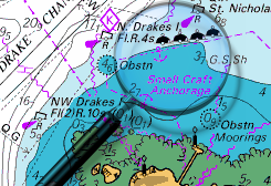
At high water there looks to be a vast expanse of water available to the West of Holehaven Point, but in fact the channel is very narrow and steep too. The entrance can be identified by the long jetty sticking out into the Thames to the West of the Creek entrance.
Make your entrance close to the Canvey Shore, there should be in the region of 1.5 m even at LWS and this deepens out as you get further in. Watch the line of fishing boat moorings carefully and as you move up the Creek keep these close to port. A series of stone groynes project from the eastern shore down to about the low water mark. A bridge structure crosses the Creek a little way in and this has 10 m clearance, so unless you're certain your mast will fit underneath that's as far as you'll get. Temporary anchorage with good protection from the East is available here.
Berthing, Mooring & Anchoring
Ray Gut can provide a useful Anchorage for even deeper draft craft on a temporary basis.
Although it doesn't look too promising on the chart, it is not as totally exposed as it looks. If the wind is in the North you have the lee of the land, while if it has South or Southwest in it, the extensive drying banks to windward will give you some shelter from the waves.
At low water within the gutway, all will be calm but as the tide gradually covers the steep banks things will get more lively. Even at high water the banks take some sting out of the waves.There are no facilities nearby and anchoring here can feel very isolated, especially when the tide is fully in and you appear to be anchored in the middle of nowhere.The holding ground is good but it may be worth buoying your anchor in case it fouls any old ground tackle on the seabed.
The other possible mooring options are Smallgains Creek (Canvey Island) and Benfleet Creek, both only suitable for boats able to take the ground. Holehaven on the other side of Canvey Island can provide a deeper water anchorage. These are now described:
Smallgains Creek.
It would be unwise to enter here unless you have previously arranged a mooring or need to get diesel (phone beforehand to check). There are two mooring opportunities here, Island Yacht Club may be able to accommodate you, try telephoning 01268 510360, and a link to their website is provided below:
The other place is what always used to be known as Halcons Boatyard, but is now under new management. They provide berths with somewhat more water than available in Benfleet Creek, with fuel and freshwater. Repairs can be handled with a dry dock and lifting facilities. They are now known as A W Marine, Office Telephone Number 07984 528881 (1000 to 1400 weekdays) or to arrange a mooring phone their HM (Dave Powell) on 07900 517906. The can take visiting boats up to about 1.5m draft, and charge £4.45 a DAY, (though, talking to Dave, they don't normally bother for just a day!) with catamarans charged more. They have shore power available on prepayment cards.Abandoning your craft for awhile could be an option here. Showers and toilets are available, takeaway food is within walking distance and there is a new cafe as well; but finding a watering hole will require a short cab ride.
Benfleet Creek.
Again unless you have pre-arranged business it would be unwise to go poking up here in a yacht. Benfleet Yacht Club is welcoming to visitors from other yacht clubs who make the effort to reach them, but it is best to make prior arrangements. They can be contacted on 01268 792278, and a link to their website is also provided:
http://www.benfleetyachtclub.org/
Dauntless Yard can handle repairs and liftings and may be able to offer you a drying mooring, they are on 07771 944288. Link Below:
http://www.dauntlessyachtcentre.co.uk/
Holehaven.
There is not an awful lot of room to swing in this Creek and avoid the moorings too. The deepwater lies on the Western side and beware of the stone groynes on the eastern side. Nothing much around this Anchorage other than the Lobster Smack Pub behind the sea wall at a Holehaven Point. This establishment seems to have been here forever, even being mentioned by Charles Dickens in Great Expectations. It's restaurant is very popular and may need booking in advance.
Facilities
If you're at anchor there are no boating facilities at hand close by. Fuel is obtainable at Smallgains Creek, or from Mikes Boatyard in Leigh on Sea who also sells gas. Either of these will need an expedition at high water.
Along the seafront from Leigh on Sea towards Southend there are various yacht clubs whose details will be found in the directory. Any approach to this area will need plenty of water and the ability to take the ground should you stay.
Transport from the area is covered by a good rail connection to London Fenchurch Street.
At Two Tree Island, the slipway is under the control of the local council. You can contact the foreshore office on 01702 611889. Trailer Sailers can launch from here with either one off charges or an annual permit. Proof of insurance needs to be shown to the warden who is on-site during the summer. If at anchor nearby water can be obtained here by jerry can when it's attended.
As mentioned before both Smallgains Creek and Benfleet Creek have their own boatyards, while there are a further couple of boatyards on the seafront at Leigh on Sea. They should all be in the directory, and may be able to assist if repairs are required.
Chandlery is available at Benfleet and Leigh on Sea.
If berthing with either of the yacht clubs water will be obtainable, and decent meals and bar snacks are certainly available at Benfleet Yacht Club, should you be intrepid enough to work your way up there.
Basic provisioning can be handled from Smallgains Creek or Benfleet Creek, but may need a bit of an expedition inland...
History
Canvey Island (area 18.45 km²; pop. 37,479) is a civil parish and reclaimed island in the Thames estuary separated from the mainland of south Essex by a network of creeks. Lying below sea level it is prone to flooding at exceptional tides, but has nevertheless been inhabited since the Roman invasion of Britain. The island was mainly agricultural land until the 20th century when it became the fastest growing seaside resort in Britain between 1911-1951. The North Sea flood of 1953 devastated the island costing the lives of 58 islanders, and led to the temporary evacuation of the 13,000 residents. Canvey is consequently protected by modern sea defences comprising 15 miles (24 km) of concrete seawall. Canvey is also notable for its relationship to the petrochemical industry. The island was the site of the first delivery in the world of liquiefied natural gas by container ship, and later became the subject of an influential assessment on the risks to a population living within the vicinity of petrochemical shipping and storage facilities. Notable residents of the island have included Roland and Francis Prout; 20th century pioneers of catamaran design, the pub rock band Dr. Feelgood, and the Olympic decathlete Dean Macey.
Petrochemical industry
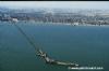
The southern area of the Canvey Island West ward at Hole Haven has predominantly existed as petrochemical site since the first construction of an oil terminal there in 1936. In 1959, as part of a pioneering Anglo-American project designed to asses the viability of transporting liquefied natural gas overseas, a gas terminal with two one thousand tonne capacity storage tanks was constructed at the site alongside the oil terminal. The gas terminal built by the British Gas Council was designed to store and distribute imported gas to the whole of Britain via the facilities at Thames Haven and the local refinery at Shellhaven in Coryton. The first delivery of 2020 tonnes arrived on 20 February 1959 from Lake Charles, Louisiana by a specially modified liberty ship Normarti renamed The Methane Pioneer. The success of seven further deliveries over the following 14 months established the international industry for transporting liquefied natural gas by sea, but the discovery of oil and gas in North sea limited further British development.
The disused storage tanks at the Occidental site in 1997.
Planning permission was granted in the following years for Occidental Petroleum and the Italian oil company, United Refineries Ltd to develop a site further west for the construction of an oil refinery, but a report in 1975 by the Health and safety executive concluded that the residents of the island faced an unacceptable risk, which led to the permission being revoked. The issue of risk was again highlighted in an attack by the Provisional Irish Republican Army in January 1979 on a storage tank at the island's Texaco oil terminal. A bomb was detonated at a tank containing aviation fuel, but failed to ignite with the fuel escaping into a safety moat. The Occidental site was abandoned in 1975 leaving a half-built oil refinery, storage tanks, and an unused mile long jetty which cost around £10 million of the approximate total of £60 million spent on the project. However, in the following years the disused and undisturbed site flourished as a haven for wildlife, and in 2003, the final storage tanks were removed in a clean-up operation, and the site was renamed as Canvey Wick and opened as a nature reserve.
Developments in the 20th century have produced a marked contrast between the environments in the east and west of the island. The eastern half of the island is allocated to residential areas, the main public amenities, and a small holiday camp and seafront, while the western half of the island is mainly farmland, marshes, and industrial areas. The marshes in the west include the 30 hectares known as West Canvey marshes acquired by the RSPB in 2007, and the Canvey Wick nature reserve. "Canvey Wick" is a designated Site of Special Scientific Interest (SSSI) at the site of the abandoned and incomplete oil refinery. Because the foundations of the 100-hectare site were prepared in the 1970s by laying thousands of tonnes of silt dredged from the Thames; the abandoned and undisturbed area has flourished as a haven for around 1,300 species of wildlife, many of which are endangered or were thought to be extinct; including the shrill carder bee, the emerald damselfly and the weevil hunting wasp. It has been said that the site may exist with one of the highest levels of biodiversity in western Europe. Other areas of natural interest include the eight hectares of Canvey Lake Local Nature Reserve owned by Castle Point Borough Council. The lake existed as a means to facilitate the salt-making process during the Roman settlement of the island, and is also thought to have functioned as an oyster bed. At the eastern point of the island is the 36-acre Canvey Heights Country Park which was reclaimed from the Newlands landfill site that operated there between 1954-89. The park is the highest land elevation on the island and subsequently provides wide views across the creeks, marshes and along the Thames. The environment supports an array of wildfowl such as skylarks, dark-bellied brent geese, and grey plover.
Landmarks
The Lobster Smack Public House at the south west corner of the island is a grade II listed building dated to the 17th century. The pub was known to Charles Dickens who mentioned it in Great Expectations. Alongside the pub is a row of wooden Coast guard cottages that date from the late 19th century which are also of grade II listed status.
Landmarks from the era of Canvey's development as a seaside resort in the 20th century include the International style Labworth Café built 1932-33 and designed by Ove Arup. The building fell into a state of disrepair in the 1970s and 80s but was renovated in 1996 and now functions as both a beach bistro and restaurant.
Opened in 1979, the Heritage Centre along Canvey Road is housed in the former St. Katherine’s Church, which was built in 1874. Originally timber-framed, the church was rendered over in the 1930’s to give it its present appearance; it closed as a place of worship in 1962. It now contains an art and craft centre with a small folk museum.
Water sport
Water sports are also popular recreational pursuits. Canvey has two sailing clubs in The Island Yacht Club and the Chapman Sands Sailing Club, with Benfleet Yacht Club and slipway also situated on the island at Benfleet Creek in the north. A region between Thorney bay and Labworth beach is designated by the Port of London Authority as an approved windsurfing area.
Eating, Drinking & Entertainment
If berthed with either of the clubs you will be able to get food and drink at the weekend, or all week in the case of BYC.
In Hole Haven there is the Lobster Smack not far away in the dinghy, and at Halcon's Yard there are pubs within walking distance.
Links
|

Got a comment to make about the Canvey Area ? Have you found this coverage helpful ? HAVE YOUR SAY (your email address will always be kept private)
Your Ratings & Comments
They have new website: https://dauntlessboatyard.com/
and the chandlery: http://www.dauntlessyachtcentre.co.uk/
both sites have their phone numbers in contact details
cheers