
You are viewing the expanded version of this Marina,
for faster browsing
use the regular version here


Thames 1, from Holehaven to the Thames Barrier.
Courtesy Flag
Flag, Red EnsignWaypoint
None GivenCharts
Admiralty 2484, SC5606Rules & Regulations
Small Craft to keep away from oil terminals, see text.Hazards
LOTS of shipping, unrestricted speed up to London.Tidal Data Times & Range
HW Dover + 0250 at London Bridge approx, MHWS 7.0m, MHWN 5.9m, MLWN 1.3m, MLWS 0.5m at London Bridge. We give a link to the Tide tables for Tilbury. (links)This site is designed for slower, roaming broadband connections, like you would get at sea, so it needs JavaScript enabled to expand the text.
General Description
The River Thames from Hole Haven onwards.....
.... takes on a completely different character from the large open expanses of the Thames Estuary. It narrows down and runs through many reaches and bends before arriving at the Thames Barrier.
It is heavily in use by commercial traffic, including large ships, and anyone contemplating making their way to London by boat needs to thoroughly familiarise themselves with the rules and regulations for avoidance of collisions.
It is around 40 miles from the entrance of the Medway or Hole Haven to London, and with a bit of planning it can be accomplished on one tide. It is worth noting that once committed to making the passage there aren't really any sheltered places to bring up at anchor...
It is also very wise to pre book your berth at one of the marinas in London before starting out, as they can often fill up.
This article covers most of this trip and describes what you're likely to encounter on the way. It takes you as far as the Thames Barrier, and in this particular stretch there are possible mooring options at Gravesend and at Gallions Point Marina in the Beckton area of East London, as well as an Anchorage possibility in the area of Mucking Flats, which is quite close to Hole Haven.
A separate article covers from the Thames Barrier up to Tower Bridge and includes the four London marinas. Progress for masted vessels terminates in the region of Tower Bridge, but motorboats can carry on and find many further facilities up to the locks at Teddington and beyond.
For the most part the scenery is grim and industrial in the section now described, but once past the Thames Barrier you can enjoy a view of London that is unequalled.
Approach
If planning to navigate through the area described....
.... and get to one of the central London marinas it would be wise to do two things, firstly book your berth with one of them, and secondly check that the Thames Barrier is not going to be closed completely on the day you plan to sail.
Contact details for the marinas are given later, and you can telephone the Thames Barrier Control on 020 8855 0315 to check. The link below gives details of Thames Barrier closures this summer (2021):
https://www.gov.uk/guidance/the-thames-barrier#forthcoming-scheduled-closures
Unless you have an extremely fast motorboat (speed is unrestricted in this stretch), you will have to plan to use the tides for this 40 mile plus passage. Bearing in mind the tidal streams can reach 4 kn in the River, and that high water at London comes about an hour later than high water around Southend, you can carry seven hours of fair tide. Even so you will have to maintain a steady pace, and it is unlikely you will be able to get much sailing in, if any.
Ideal points of departure are from Queenborough in the West Swale, or possibly from the Anchorage at Hole Haven, Canvey.
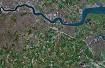
There are aerial photographs in the Gallery up on the right hand side of this page; you will find them useful
Pilotage Directions...
The harbour authority here is the PLA, and they work on VHF channel 68 as far in as Crayfordness, and on channel 14 above Crayfordness (including the Thames Barrier). A link to their website is included below:
with a link to the pla guide to recreational sailors at
http://www.boatingonthethames.co.uk/
The following link covers safety aspects in the River Thames:
http://server2.pla.co.uk/Safety
The Passage Upriver:
The first part of the journey needs to be made South of the Yantlet Channel to avoid tanker jetties and associated activity at Canvey, Shellhaven, and Coryton. The Port of London Authority recommends that all pleasure craft inward or outward bound keep South of the North Cardinal E.Blythe Buoy (Fl(2)R.10s), the northerly Cardinal buoy Mid Blyth (Q), and the red can W.Blyth (Fl(4)R.15s). We talked to LPA this spring (2022) and confirmed this; the Yantlet Secondary Channels are for use by the smaller freighters - ignore them and their directional arrows.
If emerging from the Medway the following buoys can be left to port, the green conical Grain Edge, the red can Nore Swatch, the green conical Mid Swatch, and the red can West Nore Sand.
The southern edge of the main shipping channel is then followed by leaving all three Blyth buoys on your starboard side, while not drifting too far south bearing in mind the drying Blyth Sands to port of you. As you will be leaving this area at low water careful attention will be required.
If leaving from Hole Haven, the recommended course of action is to cross the shipping channel by heading south when the coast is clear, and then tracking just outside of it to the South as described above.
If you are unfamiliar with this area take note that this shipping channel is heavily used, and you will need your wits about you.
Once past the Lower Hope red can buoy (which you have left to starboard) and abeam Lower Hope Point, the River narrows down and it is time for you to crossover to the starboard side, and for the rest of your journey now always keep to starboard. A recommended track is shown clearly on the UKHO chart and at high zoom on Navionics.
This is Lower Hope Reach, astern of you is a series of green conical buoys on your starboard side, all charmingly named "Mucking", 1,3,5 and 7. There is room to anchor should it be necessary well outside of the Mucking buoys, note the foul area marked on the chart and the Mucking Barge Roads also marked.
After Mucking No.7 Green buoy you pass the green conical buoy Bell Ovens (Q.G), with its red can partner Higham (Fl(2)R.5s) and generally south westerly course will bring you to the South Cardinal buoy Tilbury (Q(6)+LFl.15s). This is left on your starboard side or close to port and a slightly more westerly course will take you past the green conical Diver buoy (Fl.G.10s) also to be left to starboard. This is the last of the buoyage for now and the River is constrained by banks and easy enough to follow.
It is worth noting that a series of groynes have been built radiating out from the northern shore in this area. Their southern extremities are marked by posts with conical top marks and green lights, while the inner ends are marked by posts with yellow X top marks. It is essential small boat Mariners do not get inshore of the green beacons. If making a night transit note that there are a total of six of these groins,all flashing green every 2.5 seconds and in the middle of them is the Diver SHM flashing green every 10 secs - and you can bet your bottom dollar it won't have a big flashing neon sign saying "Here I am"!!!!
Until now the river has been quite wide and will begin to narrow a little from over three quarters of a mile wide coming down to only about 4 cables in places. It will continue to narrow from here up to Tower bridge.
This is Gravesend Reach, home to Gravesend Sailing Club, the Embankment Marina and the PLA pilots and authorities. There are mooring opportunities here, including the Gravesend Sailing Club and the Embankment Marina described later. These can be a little hard to spot on the South bank of the River, but they come up about 500 m before the town, the club has a flagpole and the gated entrance to the Marina faces North West. They are backed by the two domes of the Sikh temple. A sufficient rise of the tide is needed to reach either, and yachts may be seen moored in the tideway or dried out on the mud.
The northbank of the River is busy as you pass through Gravesend Reach with the cruise ship terminal and Ro Ro berths. As the River bears round from the West to the north-west the entrance to Tilbury Docks faces West on to the River. Keep a listening watch on VHF channel 68 for news of ship movements out of these docks, and be prepared because Tilbury is quite a busy dock An infrequent ferry also crosses the River at Gravesend.
Heading north west up Northfleet Hope you'll see a grain terminal on the starboard side with two green conical buoys following on your starboard side ( White Hart (fl.G.5s) and Black Shelf) with a matching red can buoy off Broadness (fl(2)R.5s). This trio marks the turn of the River to the South West into Clements Reach.
Before you reach the White Hart Green buoy you may notice the Thurrock Yacht Club on the starboard side identifiable by three whitish tower blocks and yacht moorings. It may be possible to borrow a vacant mooring here and contact details are given later. Another possibility is to anchor clear of the moorings and well out of the channel in water too shallow for ships to bother you.
Following the run of the River round to the South West into Fiddlers Reach and then swinging to the North West again into Long Reach you will have to pass under the QE2 Bridge and in this stretch the tide can run hard. The bridge has 54 m of clearance so should be no problem for yachts. More shipping berths are encountered in the vicinity of this bridge, but as you push on towards Crayfordness the industrial style scenery changes for the better and you will probably see less heavy shipping.
Once past Crayfordness change your listening watch to VHF channel 14. You are now in Erith Rands, and on the southern shore you will see the club ship belonging to Erith Yacht Club, plus it's yacht moorings. The club can often supply a mooring buoy, and anchoring is possible upstream. The details are given later.
The River swings northerly with the environment turning industrial again, a landfill site on the North at Rainham followed by the Ford motor plant, whilst on the South side there is a futuristic looking sewage works.
Just past this there is a NCM on an "Outfall" - that is quite a big construction about 20 or thirty yards across and ten or so feet high.
Much of the traffic you will see from now on are sewage ships and barge trains containing London rubbish. These are obviously not too manoeuvrable so beware.
Once past Cross Ness (11.5 miles from London Bridge) you will see the urban sprawl of the Thamesmead estates to the South of you and you are about 11 miles from London.
On the Northbank there is a large illuminated board being the signal station downstream for the Thames Barrier. It will normally inform you to call London VTS on VHF channel 14. Amber lights displayed here warn you to proceed with extreme caution, while red lights mean that navigation within the zone is prohibited. You are being observed by the gimlet eye of the Thames Barrier control centre. They also have the ability to boom out audio instructions at you from here.
If planning to pass through the barrier contact control and let them know where you are and what you are planning to do. They will give you instructions and let you know which span to pass through. You are about 3 miles away at the moment.
Before you reach the Barrier, you will have to contend with the Woolwich Ferries which cross the river just past Gallions Point Marina, they are relentless in their activity and work on VHF channel 14.
The spans are very clearly marked with green arrows showing you which gap to use, and red crosses showing you which gaps are closed.
Anyway after passing the illuminated board that has the capability of shouting at you, the River swings round to the South West in Gallions Reach and here is your final opportunity for mooring covered by this article.
Gallions Point Marina is housed in the entrance to the Royal Albert Dock, and is readily identified with the lock gates being just downstream of a conspicuous oblong building with "Royal Docks Campus" displayed. Entry through the lock is possible five hours either side of high water. More on these facilities later.
Should the Thames Barrier itself be closed you won't be able to get in or out of the Marina either because there is a floodgate that works in unison with the barrier blocking the docks. Hence the importance of checking for the normal operation of this barrier before setting out...
Berthing, Mooring & Anchoring
The passage up the River to the Thames Barrier has already been described,
so this section deals with mooring possibilities for the yachtsman or motorboater en route. They are covered in the order you will come across them as you head up River, and this area coverage ends at Galleons Point Marina, near the Thames Barrier...
The PLA website now carries a complete chart of the Thames and all the facilities along its banks and you can find it with this link:
http://www.boatingonthethames.co.uk If you scroll down that, you will find the chart which also works on our smart phone app(lication)
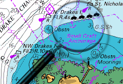
Mucking Flats Anchorage:
This anchoring possibility lies inshore of the green conical "Mucking No 5" and "Mucking No 3" Buoys. It is well out of the main channel but so close to Hole Haven or The River Medway (which are better anchorages) that is probably not worth bothering with. It could be handy in an emergency though, but when anchoring keep clear of the foul ground shown on the chart. Nothing ashore, no facilities, miserable surroundings.
Gravesend:
The PLA maintains some moorings here upstream from the Gravesend Sailing Club. Their launches are often around this area, and they listen out on VHF channel 68. Contact them for advice.
No dedicated visitors mooring, but there is often an empty buoy available, for craft up to 32 feet. The pontoon at the sailing club dries three hours after high water and can't be used for prolonged stays. See Google maps satellite view for a good look at the channel leading to the club's pontoon and the marina entrance.
The club Duty Officer can be contacted on 07506 367699, and we've provided a link to their website below:
The Embankment Marina
This is based in an old canal and was dredged within to approximately 2 m. They are warning that there may be less than that so check with them. They do have a pontoon out on the river if pushed. Entrance is via a gate (as opposed to a lock), and it can only open at best for 1 hour before high water, depending on the rise of the tide. Gate opening hours are between 8 AM and 8 PM in the summer and 10 AM to 4PM in the winter. Fuel is available here but only when there is enough water to reach the marina gate. Fuelling up does not involve actually getting into the marina.
The entrance gate is adjacent to the Gravesend Sailing Club's premises.
Contact the Marina on 01474 535700, and we provide a link to their website below:
Water and electricity are available here, with showers and toilets ashore. Calor gas can be obtained and there is a Chandler in the town. Prices here (2022) work out at £25 + VAT for up to 12 m.
Thurrock Yacht Club:
This club may have a spare temporary mooring available for you, and the clubhouse is open Thursday evenings and all weekends. The most westerly mooring on their outer trot is designated for visitors and they would like a donation of anything from £10 upwards!! Only use their outer trot if the visitors buoy is occupied. If the Club is closed their gates will be so you won't be able to access the town. Thursdays is "Club Night and they have a Saturday series. Contact them on 01375 373720 with a link to their website below:
http://www.thurrockyachtclub.org.uk/ Their stuff for visiting boats is in the "About" section
When the club is open they have showers and toilets available.
Erith Yacht Club:
This club was based in the old car ferry "Fogelforn". In 2010 they opened a new Clubhouse with a floating pontoon outside. Their pontoon is a half tide affair but they are not keen for cruisers to dry out on it. A temporary mooring can often be found for boats up to 35 feet long; try calling them on 0845 0941328, or email their secretary, with a link to their site below: The clubhouse and bar are open on Wednesday lunchtimes and the weekends.There is an amenities block behind the work sheds if the clubhouse is closed. It's very much a member-run place so during the week the phone will only be answered if there's some one around so it's best to drop them an email if you intend stopping there They especially need early notification if you are hoping to stop for more than a tide. They tend not to charge for just a one night stop. They have a web site at:-
As mentioned before anchorage is possible upstream of the club.
Gallions Point Marina: There is no longer a marina at Gallions Point but that doesn't mean that, once the flats have been built, some upmarket firm doen't do a deal with the GLA and install a new facility with suitably inflated prices.
This just about covers the mooring opportunities in this stretch of the River, past the Thames Barrier there are several more opportunities for boats with masts, and untold places for motorboats prepared to push on..
This coverage was updated in March 2023
Further Berthing Information
If anchoring or picking up a buoy anywhere along this section of the river you will be subject to the wash of passing river traffic which will make it quite uncomfortable. Naturally this does not apply to the two marinas so should be born in mind when deciding on where to stop on the way up or down
Facilities
Facilities available have already been covered with the individual mooring places. It is considered unlikely that you will be leaving your boat to stray far if you're on a mooring in the River and most definitely not if at anchor.
If in the Gravesend area all town facilities including banks and shops together with good transport will be available close by, likewise with Erith.
If moored at Gallions Point Marina at least you are near a DLR connection, and although there didn't appear to be a lots else in the area, there's now a huge Tescos about two thirds of a mile north of here and the area close around the marina has much residential development. A short ride on the train will get you to Stratford where there are ample shops and banks for every need. The nearby areas of Beckton, North Woolwich, Custom House and Canning Town are best avoided by strangers. There is no need to fret about your boat however as there is good security at the Marina.
History
The River Thames is the second longest river in the United Kingdom and the longest river entirely in England, rising at Thames Head in Gloucestershire, and flowing into the North Sea at the Thames Estuary. It has a special significance in flowing through London, the capital of the United Kingdom, although London only touches a short part of its course. The river is tidal in London with a rise and fall of 7 metres (23 ft) and becomes non-tidal at Teddington Lock. The catchment area covers a large part of South Eastern and Western England and the river is fed by over 20 tributaries. The river contains over 80 islands, and having both seawater and freshwater stretches supports a variety of wildlife.
The river has supported human activity from its source to its mouth for thousands of years providing habitation, water power, food and drink. It has also acted as a major highway both for international trade through the Port of London, and internally along its length and connecting to the British canal system. The river’s strategic position has seen it at the centre of many events and fashions in British history, earning it a description by John Burns as “Liquid History”. It has been a physical and political boundary over the centuries and generated a range of river crossings. In more recent time the river has become a major leisure area supporting tourism and pleasure outings as well as the sports of rowing, sailing, skiffing, kayaking, and punting. The river has had a special appeal to writers, artists, musicians and film-makers and is well represented in the arts. It is still the subject of various debates about its course, nomenclature and history.
Tidal Thames
Below Teddington Lock (about 55 miles/89 kilometres upstream of the Thames Estuary) the river is subject to tidal activity from the North Sea. Before the lock was installed the river was tidal as far as Staines. London, capital of Roman Britain, was established on two hills, now known as Cornhill and Ludgate Hill. These provided a firm base for a trading centre at the lowest possible point on the Thames. A river crossing was built at the site of London Bridge. London Bridge is now used as the basis for published tide tables giving the times of high tide. High tide reaches Putney about 30 minutes later than London Bridge, and Teddington about an hour later. The tidal stretch of the river is known as "the Tideway". Tide tables are published by the Port of London Authority and are available online. Times of high and low tides are also broadcast on Twitter.
The principal tributaries on the Tideway include the rivers Brent, Wandle, Effra, Westbourne, Fleet, Ravensbourne (the final part of which is called Deptford Creek), Lea, Roding, Darent and Ingrebourne. At London, the water is slightly brackish with sea salt, being a mix of sea and fresh water.
This part of the river is managed by the Port of London Authority. The flood threat here comes from high tides and strong winds from the North Sea, and the Thames Barrier was built in the 1980’s to protect London from this risk.
There is evidence of human habitation living off the river along its length dating back to Neolithic times. The British Museum has a decorated bowl (3300-2700 BC), found in the River at Hedsor, Buckinghamshire and a considerable amount of material was discovered during the excavations of Dorney Lake. A number of Bronze Age sites and artifacts have been discovered along the banks of the River including settlements at Lechlade, Cookham and Sunbury-on-Thames. Some of the earliest written accounts of the Thames occur in Julius Caesar’s account of his second expedition to Britain in 54BC[10] when the Thames presented a major obstacle and he encountered the Iron Age Belgic tribes the Catuvellauni and the Atrebates along the river.
Under the Emperor Claudius in AD 43 the Romans occupied England and, recognising the River's strategic and economic importance, built fortifications along the Thames valley including a major camp at Dorchester. Two hills, now known as Cornhill and Ludgate Hill, provided a firm base for a trading centre at the lowest possible point on the Thames called Londinium where a bridge was built. The next Roman bridge upstream was at Staines (Pontes) to which point boats could be swept up on the rising tide with no need for wind or muscle power. Many of the Thames’ riverside settlements trace their origins back to very early roots and the suffix - “ing” in towns such as Goring and Reading owe their origins to the Saxons. Recent research suggests that these peoples preceded the Romans rather than replaced them.[11] The river’s long tradition of farming, fishing, milling and trade with other nations started with these peoples and has continued to the present day. Competition for the use of the river created the centuries-old conflict between those who wanted to dam the river to build millraces and fish traps and those who wanted to travel and carry goods on it. Economic prosperity and the foundation of wealthy monasteries by the Anglo-Saxons attracted unwelcome visitors and by around AD 870 the Vikings were sweeping up the Thames on the tide and creating havoc as in their destruction of Chertsey Abbey.
Once King William had won total control of the strategic Thames Valley he went on to invade the rest of England. He had many castles built, including those at Wallingford, Rochester, Windsor and most importantly the Tower of London. Many details of Thames activity are recorded in the Domesday book. The following centuries saw the conflict between King and Barons coming to a head in AD 1215 when King John was forced to sign the Magna Carta on an island in the Thames at Runnymede. This granted them among a host of other things under Clause 23 the right of Navigation. Another major consequence of John’s reign was the completion of the multi-piered London Bridge which acted as a barricade and barrage on the river, affecting the tidal flow upstream and increasing the likelihood of freezing over. In Tudor and Stuart times the Kings and Queens loved the river and built magnificent riverside palaces at Hampton Court, Kew, Richmond on Thames, Whitehall and Greenwich.
The 16th and 17th centuries saw the City of London grow with the expansion of world trade. The wharves of the Pool of London were thick with seagoing vessels while naval dockyards were built at Deptford. The Dutch navy even entered the Thames in 1667 in the raid on the Medway.
A cold series of winters led to the Thames freezing over above London Bridge, and this led to the first Frost Fair in 1607, complete with a tent city set up on the river itself and offering a number of amusements, including ice bowling. In good conditions barges travelled daily from Oxford to London carrying timber and wool, foodstuffs and livestock, battling with the millers on the way. The stone from the Cotswolds used to rebuild St Paul’s Cathedral after the Great Fire in 1666 was brought all the way down from Radcot. The Thames provided the major highway between London and Westminster in the 16th and 17th centuries and the clannish guild of watermen ferried Londoners from landing to landing and tolerated no outside interference. In AD 1715 Thomas Doggett was so grateful to a local waterman for his efforts to ferry him home pulling against the tide, that he set up a rowing race for professional watermen known as “Doggett's Coat and Badge”.
By the 18th century, the Thames was one of the world's busiest waterways, as London became the centre of the vast, mercantile British Empire and progressively over the next century the docks expanded in the Isle of Dogs and beyond. Efforts were made to resolve the navigation conflicts up stream by building locks along the Thames. After temperatures began to rise again, starting in 1814, the river stopped freezing over completely. The building of a new London Bridge in 1825, with fewer pillars than the old, allowed the river to flow more freely and reduced the likelihood of freezing over in cold winters.
The Victorian era was an era of imaginative engineering. In the 'Great Stink' of 1858, pollution in the river reached such proportions that sittings at the House of Commons at Westminster had to be abandoned. A concerted effort to contain the city's sewage by constructing massive sewers on the north and south river embankments followed, under the supervision of engineer Joseph Bazalgette. Meanwhile, similar huge undertakings took place to ensure water supply, with the building of reservoirs and pumping stations on the river to the west of London. The embankments in London house the water supply to homes, plus the sewers, and protect London from flood. The coming of rail added both spectacular and ugly railway bridges to fine range of earlier road bridges but reduced commercial activity on the river. However sporting and leisure use increased with the establishment of regattas such as Henley and The Boat Race. On 3 September 1878, one of the worst river disasters in England took place, when the crowded pleasure boat Princess Alice collided with the Bywell Castle, killing over 640 people.
The growth of road transport and the decline of the Empire, in the years following 1914, reduced the economic prominence of the river. During World War II the protection of the Thames was crucial to the defence of the country. Defences included the Maunsell forts in the estuary and barrage balloons to cope with the threat of German bombers using the distinctive shape of the river to navigate during The Blitz. Although the Port of London remains one of the UK's three main ports, most trade has moved downstream from central London. The decline of manufacturing industry and improved sewage treatment have led to a massive clean-up since the filthy days of the late 19th and early- to mid-20th centuries, and aquatic life has returned to its formerly 'dead' waters. Alongside the river runs the Thames Path, providing a route for walkers and cyclists.
In the early 1980s a massive flood-control device, the Thames Barrier, was opened. It is closed several times a year to prevent water damage to London's low-lying areas upstream (as in the 1928 Thames flood for example). In the late 1990s, the 7-mile (11 km) long Jubilee River was built, which acts as a flood channel for the Thames around Maidenhead and Windsor.
The river is navigable to large ocean-going ships as far upstream as the Pool of London and London Bridge. Although London's upstream enclosed docks have closed and central London sees only the occasional visiting cruise ship or warship, the tidal river remains one of Britain's main ports. Around 60 active terminals cater for shipping of all types including ro-ro ferries, cruise liners and vessels carrying containers, vehicles, timber, grain, paper, crude oil, petroleum products, liquified petroleum gas, etc. There is a regular traffic of aggregate or refuse vessels, operating from wharves in the west of London. The tidal Thames links to the canal network at the River Lea Navigation, the Regent's Canal at Limehouse Basin, and the Grand Union Canal at Brentford.
There is no speed limit on the Tideway downstream of Wandsworth Bridge, although boats are not allowed to create undue wash. Upstream of Wandsworth Bridge a speed limit is in force for powered craft to protect the riverbank environment and to provide safe conditions for rowers and other river users. The speed limit of 8 knots (15 km/h) applies to powered craft on this tidal part and 4.3 knots (8 km/h) on the non-tidal Thames.
The text on this HISTORY page is covered by the following licence
http://en.wikipedia.org/wiki/Wikipedia:Text_of_the_GNU_Free_Documentation_License
Eating, Drinking & Entertainment
Again as far as traversing this area is concerned it is unlikely you will stray far from your boat unless it is safely in the Marina.
If berthed at Gravesend you won't be too far from the town facilities and there will be no problem finding pubs and restaurants etc.
If berthed within Gallions Points Marina your proximity to the DLR is your key to enjoying London. Do not for one minute think that your immediate environment is typical of London. Set out early buy a one-day travel card and go do some sightseeing. The transport system in and around London is remarkable, and it is well beyond the scope of this article to educate you about the delights of London Town. Suffice to say you could easily spend a week or two moored up using your boat as a base to go exploring. The purchase of a good guidebook would be worthwhile, avoiding the rush hours would be sensible, and keeping your wits about you while trying not to look like a tourist will keep you out of trouble.
Links
|